| #805. |
Geologists and Volcanologist tour of
Kamchatka |
The northwesterly movement of the Pacific plate has
created the Kamchatka volcanic province. This is one of the world's finest
example of large scale subduction of an oceanic plate at a very active
convergent boundary. The result is a chain of very large andesitic
stratovolcanoes. In typical plate boundary style, the volcanic zone
includes some more explosive, caldera-forming diacritic volcanic centers,
and also basaltic centers that are 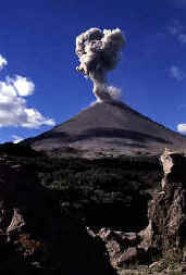 producing more mildly
explosive cinder cones and shield volcanoes. Continued northwestern
movement, at a rate of about 80mm per year, of the Pacific Ocean plate
causes its subduction beneath Kamchatka. A long history of plate
convergence has created parallel volcanic mountain belts that now form the
core of the Kamchatka peninsula. producing more mildly
explosive cinder cones and shield volcanoes. Continued northwestern
movement, at a rate of about 80mm per year, of the Pacific Ocean plate
causes its subduction beneath Kamchatka. A long history of plate
convergence has created parallel volcanic mountain belts that now form the
core of the Kamchatka peninsula.
The eastern mountain range
is the youngest and contains all the active volcanoes except Ichinsky,
which is now only fumarolic. Many of the major eruption deposits have been
dated by potassium-argon and radiocarbon methods. Most of the calderas
date from about 30,000 to 40,000 years ago, and most of the present cones
on the stratovolcanoes have formed entirely in the last 20,000 years.
Kamchatka's line of volcanoes continues southwards along the Pacific
margin, through the Kuril Islands and into Japan. Clockwise around the
Pacific rim, the volcanoes continue in the Aleutian Islands into Alaska.
The gap between Kamchatka and the Aleutians is marked by the shear zone
along the Bering Fault, a passive transform plate boundary with no
subduction and therefore no volcanoes. It meets the Kamchatka coast just
north of Shiveluch, and there are therefore no volcanoes further
north.
9 DAY ITINERARY
Day 1. Arrive at Petropavlovsk airport. The new road
for 24 km into Petropavlovsk is across farmland on the alluvial flats
of the Avacha River.
The Petropavlovsk Hotel is just off the main road
in the outskirts of the city. A short evening walk around can provide a few initial
glimpses of Russian life on the streets.
Day 2. Breakfast
in hotel. Pack most of your supplies in your main case, and leave it
in the pile in the reception area. Wear boots and warm outdoor gear. Pack
in a small bag one set of spare clothes, extra sweater, overnight kit etc.
and torch - the minimum for one night away between two days of walking;
have your sleeping bag in there too, or have it separate; and ensure that
you can identify your own bag and sleeping bag; have anorak, camera, film
etc. with you; no food is needed. Leave hotel by 6WD bus.
 Head out of Petropavlovsk for
18 km along the road towards Yelisovo city. Turn off right onto a track,
past a small village, and on through birch woods. The route disintegrates
into not much of a track up an almost dry river bed. The channel is active
annually in melt-water and storm floods; it is also sporadically modified
by lathers during activity on the volcanoes ahead. Red and black rounded
blocks are andesitic and basaltic lava and tephra, some with feldspar
phenocrysts; banks expose dissected debris flows and some lenses of finer
airfall ash. The route climbs away from the channel, to continues up
sloping tundra with alder and willow. The track ends at sprawling group of
cabins, 25 km from the main road; Avacha volcano is up ahead to the right,
and Koryaksky is ahead to the left. Lunch is in one of the cabins. Head out of Petropavlovsk for
18 km along the road towards Yelisovo city. Turn off right onto a track,
past a small village, and on through birch woods. The route disintegrates
into not much of a track up an almost dry river bed. The channel is active
annually in melt-water and storm floods; it is also sporadically modified
by lathers during activity on the volcanoes ahead. Red and black rounded
blocks are andesitic and basaltic lava and tephra, some with feldspar
phenocrysts; banks expose dissected debris flows and some lenses of finer
airfall ash. The route climbs away from the channel, to continues up
sloping tundra with alder and willow. The track ends at sprawling group of
cabins, 25 km from the main road; Avacha volcano is up ahead to the right,
and Koryaksky is ahead to the left. Lunch is in one of the cabins.
In
the afternoon take a gentle walk up the valley to Camel Mountain, a
distinctively humped ridge amid a group of small hills on the saddle
between Avacha and Koryaksky. The hills are mainly eroded remains of old
cinder cones, with some shoulders and summits of welded spatter. They are
mainly basaltic, with some loose blocks of lighter andesite; nodular
inclusions of dunite (almost pure mosaics of green olivine) are
collectable. Snow fields drape some of the slopes. Return to camp, for
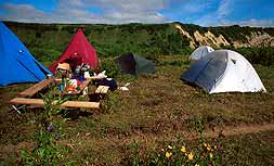
dinner, and an early night in the tents.
Day 3. Breakfast. Pack
your overnight bag and sleeping bag, and roll up your camp-mat, and put
them all in the baggage truck before setting out for the day's walk. Have
anorak, extra sweater and woolly hat on, or in a day bag. Food is not
needed. A water bottle is useful for your own drinking supply.
 Avacha volcano Avacha volcano
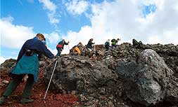
The volcano walk is on a single trail,
where members can walk as far as they wish and then return down the same
trail. People can walk at their own pace, but should avoid walking alone;
in case of accidents as trivial as a sprained ankle, it is essential to be
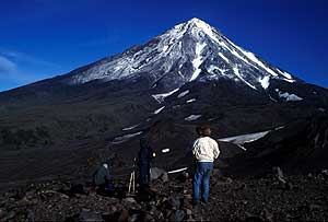
in groups of at least three. The camp is at an altitude of about 950 m,
and Avacha's summit is at 2741 m. The climb to the rim of the summit
crater involves a climb of nearly 1800 m. An easier option is to aim to
reach the shoulder on the old crater rim, which offers a lovely stretch of
scenic walking, and requires a climb of about 1100 m.
The Avacha
trail crosses the stream near camp and then heads up pyroclastic
slopes, where stream sections expose stratified lapilli tuffs; these
become steadily steeper. There are increasingly good views back to the
splendid andesite cone of Koryaksky; this rises to 3456 m and is scored by
deep gullies, but its current activity is limited to a few small
fumaroles.
The steep part of the trail ends where it turns onto a
gently rising shoulder, which provides the delightful walk on an easier
gradient. The shoulder is the rim of the early crater, formed when the
main mass of the old summit slipped in a gigantic landslide down towards
the coast, followed immediately by a massive lateral blast and
eruption. The old has been nearly filled and obliterated by the growth of
the new summit cone. It is surfaced with loose cinders which lie over
partially welded pyroclastic flows; some sections of channel are filled
with lava with rubbly tops to individual flows.
On the ancient
crater rim, there is an old volcanologist's cabin. The newer summit cone
rises above, and its northern slope overlaps and buries the old caldera
rim, so that the easy shoulder does not continue round. Andesites on the
ridge and above have 4 mm augite and 2 mm feldspar phenocrysts. There are
views south to the andesite cone of Viluchinsky and beyond to the complex
peaks of Mutnovsky and the rounded shield volcano of Gorely; to the north
lie the old degraded cones of the Zhupanovsky volcanoes.
The trail to
Avacha's summit starts up some snow fields, but then winds up the steep
cinder cone. Its surface is mainly loose, red, oxidized tephra, with areas
of airfall ashes, and there are some exposures of the underlying welded
pyroclastics.
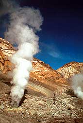
 The
summit crater yawned hundreds of meters deep until 1991, when it was
filled with andesite lava. The black lava now forms a gentle dome - it is
the fresh top of a classic plug dome. Steam rises through its fissured
surface, and there are even more fumaroles and solfataras round its edge,
at the contact with the crater walls of red pyroclastics. Walk round the
rim to the left; giant crescent flow ribs mark the lava's surface where it
moved sluggishly east and flowed over the lowest point on the old crater
rim. It flowed for a kilometer down the volcano flank, but was so viscous
that it came to rest on an angle of nearly 45¡. Climbing over the blocky
andesite is not easy, but a little scrambling reaches some active vents
lined with sulphur crystals. The rim to the right overlooks slopes of
sulphur deposits, but soon reaches the lava overflow. There are fine views
of Koryaksky and all points beyond. The
summit crater yawned hundreds of meters deep until 1991, when it was
filled with andesite lava. The black lava now forms a gentle dome - it is
the fresh top of a classic plug dome. Steam rises through its fissured
surface, and there are even more fumaroles and solfataras round its edge,
at the contact with the crater walls of red pyroclastics. Walk round the
rim to the left; giant crescent flow ribs mark the lava's surface where it
moved sluggishly east and flowed over the lowest point on the old crater
rim. It flowed for a kilometer down the volcano flank, but was so viscous
that it came to rest on an angle of nearly 45¡. Climbing over the blocky
andesite is not easy, but a little scrambling reaches some active vents
lined with sulphur crystals. The rim to the right overlooks slopes of
sulphur deposits, but soon reaches the lava overflow. There are fine views
of Koryaksky and all points beyond.
The descent of the summit cone is
on a straight steep down-trail alongside the zigzag up-trail; it requires
an element of bold scree running, with considerable care where areas of
welded tephra tend to promote spectacular somersaults. Return to the camp
before 5pm. After some modest refreshments, the bus heads back down to
Petropavlovsk. A late dinner in the Petropavlovsk, soon after we
return.
Day 4. Breakfast in hotel. Leave your things in your
room, as we return in the evening. Wear boots and outdoor gear. Have rain
gear and a spare sweater in a day bag; no food is needed; keep clutter to
a minimum as it will only be a pain in the helicopters. Leave in our own
conventional bus, for the 45 minutes drive to the heliport, at Yelisovo,
close to the main airport.
The helicopter flight to the Valley of
Geysers takes about 75 minutes, on either of two routes. The all-weather
eastern route heads round the southern and eastern flanks of Avacha,
flying at heights of just a few hundred meters above ground if that is
necessary to keep below any thick cloud cover. It continues north up a
broad valley to the east of the Zhupanovsky volcano; the low flying gives
splendid views of the taiga landscape, and this valley is home to many
brown bears, who may be easily seen from above. Over a low col, the flight
approaches the coast, where a few hunters' cabins lie among the trees;
Karymsky and the two Semlyachik volcanoes lie inland to the left. The
flight then turns inland up the valley just before the Kikhpinych volcano,
and turns into the lush green tributary which is the Valley of
Geysers.
 The western route heads round the western side of the smaller
cones of Arik and Aag, which continue the line of volcanoes northwest from
Koryaksky. It then heads across the interior tundra, keeping west of
Zhupanovsky, on its way to Karymsky If the eruptions are still in
Strombolian style, one should be seen on the flight past. The active cone
is 700 m high, and stands inside an old caldera; the even older Dvor
caldera is truncated as the higher bowl to the north. Just to the south,
Karymsky Lake lies in the Academia Nauk caldera, which erupts less
frequently. Northwards, the flight goes over Maly Semlyachik volcano with
its spectacular crater lake of green water. Past the inactive Bolshoi
Semlyachik, the route veers slightly right for the Valley of Geysers. The western route heads round the western side of the smaller
cones of Arik and Aag, which continue the line of volcanoes northwest from
Koryaksky. It then heads across the interior tundra, keeping west of
Zhupanovsky, on its way to Karymsky If the eruptions are still in
Strombolian style, one should be seen on the flight past. The active cone
is 700 m high, and stands inside an old caldera; the even older Dvor
caldera is truncated as the higher bowl to the north. Just to the south,
Karymsky Lake lies in the Academia Nauk caldera, which erupts less
frequently. Northwards, the flight goes over Maly Semlyachik volcano with
its spectacular crater lake of green water. Past the inactive Bolshoi
Semlyachik, the route veers slightly right for the Valley of Geysers.
The Valley of Geysers
The cluster of geysers,
fumaroles and hot springs in this valley were only discovered in 1941.
They lie above the marginal fractures of the oldest Uzon caldera. The hot
water that emerges is largely recirculated rainfall, mixed with some
juvenile water from magma. The magmatic heat source is probably the roots
of the Uzon volcano, where ground temperatures reach 250¡C at about 500 m
depth beneath the caldera floor; alternatively, the Kikhpinych volcano may
be the heat source. The Geysernaya River has cut its valley into bedded
andesitic tuffs that were deposited in a lake in the first Uzon caldera;
the southeastern valley slope is the heavily eroded caldera wall, broken
into older volcanic. Some dacite lavas and intrusions occur in the tuffs,
and all the exposed rocks have been altered hydrothermally. Some slopes
have been gullied to leave earth pillars. There are extensive deposits of
opaline siliceous geyserite, some built into large banks and terraces
below the main vents. The valley's geysers include a few with large but
brief periodic eruptions, and many more which produce hot water spouts
frequently or almost continuously.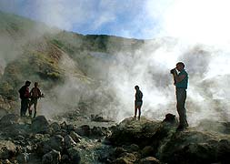
The
helicopters land in front of the timber lodge that is the access point for
all visitors to the trails into The Valley of Geysers (Dolina Geyserov),
within the Kronotsky Nature
Reserve. Walkabouts in the valley are not allowed, so we will stay in
a group.
The boardwalk leads to the lip of the valley for a fine
overall view. The upper slopes of the valley expose cliffs of pumaceous
tuffs, some eroded into earth pillars. The valley floor has a lush green
plant cover, except where active banks of geyserite have not yet been
colonized.
A branch to the left ends at the Bolshoi (Big) and Maly
(Small) Geysers. An eruption of Bolshoi, on the left, throws water about
10 m high amid clouds of steam, for about 10 minutes; it erupts on a cycle
of about 75 minute. Maly Geyser throws water out at 45¡ for about 8 m, in
eruptions lasting 5 minutes on a 35 minute cycle.
The main path
descends to a bridge over the Geysernaya River a little further upstream.
The river reaches a temperature of 26¡C with its geothermal input in the
summer; winter snow-melt reduces it to about 16¡C. Water from the springs
and geysers varies from 35¡C to 100¡C. Just upstream of the bridge, the
Schell (Crack) Geyser erupts briefly every 35 minutes; it was heavily
eroded during a typhoon flood in 1981. The Fountain Platform is a great
bank of geyserite producing copious quantities of steam from numerous
vents; it is claimed as the world's greatest concentration of geysers and
fumaroles. On the platform. Malachite Grotto is a nearly permanent spouter
erupting from a geyserite cone; the Fountain and New Fountain are
connected so that they switch their water spouts every few minutes but
combine to provide almost continuous activity.
The boardwalk ends
before another old bridge. Velikan (Giant) Geyser is on the far bank,
inside the bend of the river; it erupts with a cascade of water to heights
of about 25 m, but only for about a minute, before sending steam jets to
far greater heights for another few minutes; its cycle is around 8 hours.
A trail on the terrace above the valley floor provides views down onto the
Fountain Platform, and also passes various hot pools, blue with suspended
clay, and boiling mud pots, red with iron oxides. Lunch is scheduled at
the Valley of Geysers lodge.
The Uzon Caldera
The Uzon depression is bordered
to the north and west by steep caldera walls that have survived into the
modern landscape. These are essentially features of the second in the
series of three caldera collapses; the third (minor) collapse merely
deepened the depression west of the helipad that is now largely marsh
ground and lake remnants on a floor of lacustrine sediments. The highest
ground is formed by the basaltic cone of Uzon volcano, which stands above
the western rim of the caldera.
Immediately west of the helipad, Bannoe
Lake has a steam vent beneath it; this erupted in 1989, but is now quiet.
The lake is about 30m deep, and its bottom 7m are a pool of liquid sulphur
at a temperature of 140oC; large blocks of glassy black sulphur
have been extracted by volcanologists. It appears that the sulphur vent is
similar to the black smokers of ocean floors.
Further west, trails wind
across the marsh ground on the caldera floor to a variety of hot springs,
boiling lakes and mud pots in the dacitic tuffs and lake sediments.
Various of the hot springs have associated sulphur, opal, pyrite and
mercury deposits. Most of the colouring at the spring sites is due to
temperature-sensitive algae.
 Towards the east, a trail
leads through alder bushes up the Belaya dome; this is formed of
slab-jointed dacite porphyry that varies from dark lava and tuff to glassy
obsidian and light pumice. Some is hydrothermally altered, with kaolinite,
opal, alunite and sulphur. Adjacent to Belaya, there are two small acid
lakes with pH of 2. Further north. Lake Dalneye is nearly 1 km across, in
a splendid maar crater fringed by a tuff ring of very scoriaceous basalt;
it was produced by the modest steam explosions of a phreatic eruption from
a vent beneath the lakes and marshes of the caldera floor. Towards the east, a trail
leads through alder bushes up the Belaya dome; this is formed of
slab-jointed dacite porphyry that varies from dark lava and tuff to glassy
obsidian and light pumice. Some is hydrothermally altered, with kaolinite,
opal, alunite and sulphur. Adjacent to Belaya, there are two small acid
lakes with pH of 2. Further north. Lake Dalneye is nearly 1 km across, in
a splendid maar crater fringed by a tuff ring of very scoriaceous basalt;
it was produced by the modest steam explosions of a phreatic eruption from
a vent beneath the lakes and marshes of the caldera floor.
Return by
helicopter to Yelisovo, and by bus to the Petropavlovsk Hotel. Dinner in
hotel.
Day 5. Breakfast in hotel. Pack most of your gear in your
main case, and leave it in the reception area. Wear boots and warm outdoor
gear. Pack in a small bag one set of spare clothes, an extra sweater,
overnight kit and torch, and perhaps another change of clothes - the
minimum for two nights away between three days of walking; have your
sleeping bag in the bag or separate; and ensure that you can identify your
own bag and sleeping bag; have anorak, camera, film etc. with you; no food
is needed.
Head out of Petropavlovsk on the old road towards Yelisovo.
Turn off left across the alluvial flatlands at the mouth of the Avacha
River valley. The Paratunka Valley is a geothermal zone with a series of
hot springs along its floor. Boreholes have proved groundwater at 80 ¡C in
the porous volcanic rocks at depths of 80-100m. The heat source is magma
at depth in the fracture zone along the line of the East Kamchatka
Volcanic Belt. Buried pipelines take hot water to greenhouses and a fish
farm.
The tarred road lies along the west side of the flat valley
floor. Near the end of the farmed land, a dirt road begins; this provides
access to the Mutnovsky area for new developments in the form of a
geothermal power station and a tourist hotel (both under construction) and
also various gold ore deposits (still in the mine prospect stage). The
pylons and power lines are the environmental cost of the geothermal
resources out in the volcanic wilderness. From the road there are views
east to the splendid but inactive cone of Viluchinsky volcano, and north
along the glaciated trough of the Paratunka Valley. The road climbs a
gently sloping ridge in a lovely environment of open mountain tundra. We
stop at a viewpoint on the broad plateau east of Gorely; the shield
volcano of Gorely lies to the west, beyond the rim of its modest caldera
wall; the ice-clad ramparts of the Mutnovsky volcano lie further away to
the south; the Viluchinsky cone rises to the northeast. The onward route
depends on which campsite is used, and this depends on snow conditions
left by the summer melt after the previous winter; it cannot therefore be
known in advance.
Osvysmannye Valley is reached by turning right
onto a track that makes a steep and rough descent into the Gorely caldera.
The track continues south across a basin floor of wind-blown silt sand and
ash, and descends into the valley of the Osvystannaya River with Gorely is
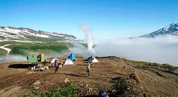
on the right. The campsite is in a beautiful and remote wilderness, with
the steep andesitic slopes of Mutnovsky rising to the south and the
gentler basaltic slopes of Gorely to the north. A short walk to the south
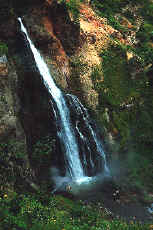
reaches the rim of the canyon that drains out of Mutnovsky; it contains
some fine waterfalls cut into the volcanic rocks, but its floor is choked
with snow many meters deep. Dinner is at camp, then an early night in the
tents.
 Dachnye Hot Springs lie ahead along the main track. The new
geothermal power station and the Mutnovsky gold deposit (with 28 tons of
gold reserves in a hydrothermal system of large quartz veins amid a
sulphide-bearing stockwork) both lie to the east in the valleys draining
to the coast. The maintained track virtually ends at the construction site
for some of the power station works and a new tourist hotel, and the
campsite is in the valley just below. Two streams converge at the
campsite; one is cold for drinking, and the other is warm for washing. A
path up the true-left bank of the warm stream is steep, wet and slippery
in places; it leads to the source of the hot water in the steam cloud of
the old volcanic vent of Aktivny. Just 200 m across, this contains a host
of hot springs, small geysers, fumaroles and boiling mud pools. They all
lie in hydrothermally altered pumice tuffs and ignimbrites. A walk
up the cold stream reveals exposures of welded ignimbrites containing
blocks up to 150 mm across that were components of the pyroclastic. All
around the site there are rusty pipes projecting from the ground and
spouting large or small flows of steam. These were all exploratory bore
holes drilled to assess the geothermal resources. Some are recent, but
others are 20 years old; treat them with respect as they have been known
to explode. Most production bore holes for the new power station are 4 km
away to the east. Dinner is at camp, then an early night in the
tents. Dachnye Hot Springs lie ahead along the main track. The new
geothermal power station and the Mutnovsky gold deposit (with 28 tons of
gold reserves in a hydrothermal system of large quartz veins amid a
sulphide-bearing stockwork) both lie to the east in the valleys draining
to the coast. The maintained track virtually ends at the construction site
for some of the power station works and a new tourist hotel, and the
campsite is in the valley just below. Two streams converge at the
campsite; one is cold for drinking, and the other is warm for washing. A
path up the true-left bank of the warm stream is steep, wet and slippery
in places; it leads to the source of the hot water in the steam cloud of
the old volcanic vent of Aktivny. Just 200 m across, this contains a host
of hot springs, small geysers, fumaroles and boiling mud pools. They all
lie in hydrothermally altered pumice tuffs and ignimbrites. A walk
up the cold stream reveals exposures of welded ignimbrites containing
blocks up to 150 mm across that were components of the pyroclastic. All
around the site there are rusty pipes projecting from the ground and
spouting large or small flows of steam. These were all exploratory bore
holes drilled to assess the geothermal resources. Some are recent, but
others are 20 years old; treat them with respect as they have been known
to explode. Most production bore holes for the new power station are 4 km
away to the east. Dinner is at camp, then an early night in the
tents.
Day 6. Breakfast. Have an anorak, extra sweater and
woolly hat on, or in a day bag. Food is not needed. A water bottle is
useful for your own drinking supply. Leave everything else in your
tent.
Mutnovsky volcano.
The volcano walk is on a single
trail there and back, and everyone should walk into the caldera. Wandering
off alone is seriously discouraged, as snow bridges, ice falls and
unstable ground on geothermal crusts all provide hazardous
environments.
 From the Osvysmannye campsite, the walk is nearly 7 km, with a
rise of less than 600 m, into the main caldera. A gentle stroll soon
starts to climb steadily on the bedded pyroclastics of the Mutnovsky
slopes beside a stream which emerges from the caldera exit gorge
ahead. From the Osvysmannye campsite, the walk is nearly 7 km, with a
rise of less than 600 m, into the main caldera. A gentle stroll soon
starts to climb steadily on the bedded pyroclastics of the Mutnovsky
slopes beside a stream which emerges from the caldera exit gorge
ahead.
From the Dachnye campsite, the walk is longer but with less to
climb. A 6WD bus goes as far as possible on a track below the two hills of
Skalisty and Dvugorby , which are volcanoes more than 20,000 years
old of pale rhyolite lavas and pyroclastics. Beyond the track, a
foot-trail climbs past more old bore holes spouting steam, to the pass
between Mutnovsky and Dvugorby, from where Asacha (left), Opala and Gorely
(right) are seen ahead. The route then makes a long traverse of the
hillside, on a mix of rough tundra, blocky andesite lava and banks of
airfall ash and pumice reworked by the wind; it crosses three broad
snow-fields, before a final rise to the mouth of the caldera exit
gorge.
The two routes meet above a short descent into the gorge. Above
the steep wall to the south, the steam plume can be seen rising above the
active crater of the volcano. Seen away to the east, there are cinder
cones and tuff rings over flank vents on the Gorely slopes.
The Mutnovsky caldera
The walk up the gorge is
largely on banks of hard snow and firn ice, that has accumulated in winter
avalanches off the gorge walls. Much of the surface is covered in
wind-blown ash, and some of it is melted into little astrugi pinnacles;
the caldera drainage flows in snow caves on the rock surface, and is
sometimes seen or heard deep in crevasses or collapse areas. The gorge
walls are cut in coarse rhyolitic pyroclastic flows laced with thin dark
dykes.
The caldera's eastern glacier lies ahead where it melts out on a
steep rock slope, aided by a series of fumaroles; steam from these has
created ice tunnels that emerge in the glacier snout.
Climb the slopes
of volcanic tephra and glacial till on the right, and descend slightly to
the snout of the western glacier, which is also advancing over fumaroles.
A way between the ice and the caldera wall passes beside various
geothermal vents; these include fumaroles, mud pools and solfataras, and
their style may change within hours as melt-water from the adjacent
glacier seeps into the ground and is boiled at very shallow depth. A lake
is sometimes dammed up behind the glacier; at other times it drains
through the ice, leaving a flat bed of reworked ash pitted by solfataras
and boiling mud-pools. Streams emerge from the snow and ice fields, and
flow back under the glacier toe.
Picnic lunch is taken at some spot
away from the fumaroles that are active at the time of the visit The
caldera floor is at an altitude of about 1540 m, which is still 800 m
below the ice-capped summit of the Mutnovsky volcano.
The walk
continues up the western snow-fields below the caldera wall cut in thinly
bedded pyroclastic flows that are probably old surge deposits. The glacier
on the left has its source in the stage 4 caldera, which has
coalesced with the main caldera that is largely of stage 3.
A steep
scramble aided by rope handlines leads up coarse welded pyroclastics to a
knife-edge ridge between the caldera and the active crater. The steam
plume from the active crater rises far above, but when the wind blows it
around, the vigorous fumaroles and solfataras that are its source can be
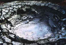
seen on the crater floor. The crater is about 350 m across, and its walls
drop nearly vertically for over 100 m to its flat floor of scree and
inwashed ash.
Return to the campsite back along the outward route.
Dinner at camp.
Day 7. Breakfast. Pack your overnight bag and
sleeping bag, and roll up your camp-mat, and put them all in the vehicle
before setting out for the day's walk. Have an anorak, extra sweater and
woolly hat on, or in a day bag. Food is not needed. A water bottle is
useful for your own drinking supply.
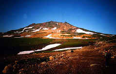
Gorely volcano
Again the volcano walk is on a
single trail there and back, where members can walk as far as they wish
and then return down the same trail. Avoid walking alone; in case of
accidents as trivial as a sprained ankle, it is best to be in groups of at
least three.
From either campsite, the 6WD buses head north to the
track round the edge of the large lake that lies in the unfilled eastern
crescent of the Gorely caldera. From the lake flats, the walk up the
volcano is about 5 km, climbing steadily to gain 750 m in height. The walk
up the huge shield volcano is over a mixture of rough grassy tundra with
very low dwarf willow and bare stripes of basaltic a lava. Some lava flow
structures are recognizable, and there are also patches of volcanic ash
redistributed by the wind.
Aim up the slope for the saddle between the
two low summits which are the raised rims of separate craters. Higher up,
long gently graded snow-fields provide the easiest route up (and certainly
the best way to come back down). The southwest crater, to the left, is
dead and rather featureless.
 Head through the saddle and then round to the right, along the
far rim of the main crater complex. The first large crater contains a cold
lake about 100 m below; its surface has ice floes from a small glacier on
its internal slope. The walls of all the craters expose profiles through
thick sequences of lava flows with a limited component of interbedded
pyroclastics. Continue beyond it to a broad shelf that extends inside the
very large old central crater. Picnic lunch on the shelf. Just ahead,
there is a sudden, unguarded, vertical descent into the active crater.
Over 100 m down, a hot acidic lake has active fumaroles and solfataras
around its margin and beneath the surface. The recent eruptions of Gorely
have been largely steam events produced when these vents heat up and
therefore increase their output. Head through the saddle and then round to the right, along the
far rim of the main crater complex. The first large crater contains a cold
lake about 100 m below; its surface has ice floes from a small glacier on
its internal slope. The walls of all the craters expose profiles through
thick sequences of lava flows with a limited component of interbedded
pyroclastics. Continue beyond it to a broad shelf that extends inside the
very large old central crater. Picnic lunch on the shelf. Just ahead,
there is a sudden, unguarded, vertical descent into the active crater.
Over 100 m down, a hot acidic lake has active fumaroles and solfataras
around its margin and beneath the surface. The recent eruptions of Gorely
have been largely steam events produced when these vents heat up and
therefore increase their output.
Return back along the outward route to
the buses by the lake. The buses head back out of the Gorely caldera, and
then return to a hotel in the Paratunka Valley. Rest and swim in poll with
thermal hot water.
Day 8. Breakfast in hotel. Leave in a
conventional bus, for the journey back to Petropavlovsk. Bring all your
baggage with you.
Boat excursion in Avacha Bay.
A
boat trip out into the bay is a very relaxing way of gaining an
alternative view of the splendid setting of Petropavlovsk and its
dramatic volcanoes. Departing from a pier near the center of town, the
expanse of the hilly city soon falls into perspective. Further toward
the middle of the bay, both Koryaksky and Avacha volcanoes come
into view behind the city. When Avacha erupted in 1991, people living
in Petropavlovsk could watch the red stream of lava coming down the
slope towards the city, while hot ashes were shooting into the skies
above the summit crater.
 Avacha Bay is
geographically as perfect a bay as a city could hope for. It is large and
deep, with a narrow opening which keeps out foul weather and ice. The
harbour is open to shipping year round, and is also well protected from
the dreaded tsunami waves that are created by earthquakes around the
Pacific Ocean margins. The boat heads toward the mouth of the bay,
allowing views of the Northwest side of Petropavlovsk and the many boats
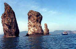
that make their home in these ports. Near the mouth of the bay, the Three
Brothers are tall finger-like sea stacks, whose rock faces rise vertically
out of the water . The cliffs around the bay house many colonies of
seabirds in their natural habitats, and puffins are commonly seen among
many other types of seabird. Avacha Bay is
geographically as perfect a bay as a city could hope for. It is large and
deep, with a narrow opening which keeps out foul weather and ice. The
harbour is open to shipping year round, and is also well protected from
the dreaded tsunami waves that are created by earthquakes around the
Pacific Ocean margins. The boat heads toward the mouth of the bay,
allowing views of the Northwest side of Petropavlovsk and the many boats
that make their home in these ports. Near the mouth of the bay, the Three
Brothers are tall finger-like sea stacks, whose rock faces rise vertically
out of the water . The cliffs around the bay house many colonies of
seabirds in their natural habitats, and puffins are commonly seen among
many other types of seabird.
Return to the Petropavlovsk Hotel for
lunch.
Volcanological Institute
The Institute is on the
old main road out of Petropavlovsk. A visit includes a short video and
presentation by one of the volcanologists to outline the volcanic features
of the Kamchatka peninsula. Emphasis is on the huge eruption of Tolbachik
in 1975/6, which was predicted after precursor earthquakes, and
which brought instant volcanic fame to Kamchatka. There is opportunity to
see the small museum, with its spectacular photographs of most of the
volcanoes. Specimens are labeled in Russian, so provide a fun
identification challenge; don't miss the huge mass of black sulphur
(looking like dull basalt glass) that came from Bannoe Lake at
Uzon.
Return to the Petropavlovsk Hotel some time in the afternoon, and
take your own walk in Petropavlovsk . Dinner is in the hotel.
Day 9.
Breakfast. Take a morning walk in the neighbourhood or take a bus into
town.
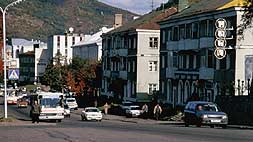
Petropavlovsk
The city of 240,000 people is spread
along the shores of Avacha Bay wherever buildings can fit between the
wooded hills. To see a little of the Russian urban lifestyle, the two
obvious alternatives are a walk in the suburbs near the hotel, and a bus
ride into the town centre or beyond. There is even time for both.
Local walk
This involves a gentle stroll to reach
various shops, markets and local sights. The main Silhouette crossroads
has a bookshop and a money exchange on one corner. Continue along the main
road to an open-air market on the left and a large department store on the
right, which together give some idea of normal shopping in Russia. Look
out for the blocks of flats just beyond. These are old and could have
collapsed in an earthquake. They now have large ribs of reinforced
concrete up their sides, with steel ties providing tension across their
roofs, to prevent oscillating shear whereby the walls fail and the
stronger floor decks pancake, to the serious detriment of the occupants.
These are now intended to be safe in any local earthquake; all the newer
blocks were built to better codes.
Head southwest to reach some older
suburbs with typical timber houses; in their midst, the Church of St.
Peter and St. Paul (like Petropavl...) has classically beautiful Russian
Orthodox gold onion-shaped spires; it is less than 30 minutes walk from
the hotel; the area offers views of Avacha Bay.
 Bus to town Bus to town
The centre of town is worth a visit; take a
bus, as it's too far to walk both ways. Bus shelters are concrete with a
big red A on the roof and a crowd in front. It is easiest to use the big
white Daewoo or green buses; numbers 1, 21 and 22 go into town, and
there's one every few minutes. Buy a ticket from the conductress on the
bus; any distance is the same fare.
The modern city centre is on the
parallel one-way roads south of Lenin's statue. The art shop has some good
material, popular with visitors (and accepts US dollar notes); it is up
the stairs through an obscure door in the back (go round to the left) of
the bank at 36 Sovetskaya Street. The Regional Museum, at 20 Leninskaya
Street has some excellent displays, and is well worth a visit. For a
scenic bus ride, stay on a number 21 bus to its terminus, way down the bay
past multiple suburbs, small bays and harbours. Lunch is in the
Petropavlovsk Hotel. Afterwards, leave by bus to the airport. Depart from
Kamchatka.
Cost EUR1750 per person.
Price includes:
- Full board
- Double accommodation in hotel in PKC and Paratunka.
- Helicopter excursion to Geysers Valley and boat excursion
- English-speaking rep at the arrival and departure in PKC airport
- Transfers by coach and 6WD bus
- City tour and museums fees
- Guide, interpreter and cook services
- Visa invitation and visa registration
- Permits
|